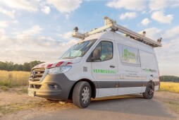
Mobile mapping: camera van on the road in Bocholt
Driving through the urban area with camera vehicles // 10 June to 5 July 2025
In cooperation with Bocholter Energie- und Wasserversorgung GmbH (BEW), the city of Bocholt is carrying out a survey of the city area from 10 June to 5 July. The so-called "Mobile Mapping" will record high-resolution image and laser data of the public urban space.
The aim is to digitise and optimise the collected data to enable it to be used for internal processes at the city and the utilities. Among other things, the data obtained is used to speed up and simplify numerous work processes.
For example, house connection planning, fault recording, the preservation of evidence for construction projects and the development of energy-efficient lighting concepts can be carried out in a much more time-saving and cost-efficient manner in future. On-site appointments can be omitted thanks to a digital inspection of the situation.
The contract was awarded to a company from Kempen, which uses camera vehicles with a 360° camera system including an integrated laser scanner to capture the data. The current survey is the fifth data collection of this kind since 2012 and is part of the city of Bocholt's ongoing digitalisation strategy.
Data protection is a top priority
The collection and processing of the image data is carried out in strict compliance with the applicable General Data Protection Regulation (GDPR). Compliance with all requirements is monitored by the city's data protection officer.
Before being used in internal administrative applications, all personal data - in particular faces and vehicle registration plates - are automatically rendered unrecognisable (pixelated). Publication of the images on the Internet is not planned; access to the data is exclusively via the city administration's internal network.


